![](/images/other/stat-length.png)
![Tocht Stappen La Souche - Rocher du Isi - Photo](https://media.geolcdn.com/t/1900/400/ext.pjpeg?maxdim=2&url=https%3A%2F%2Fstatic1.geolcdn.com%2Fsiteimages%2Fupload%2Ffiles%2F1553511878bg_sport_marche.png)
Rocher du Isi
Odile Guillot
Gebruiker
![Lengte](/images/other/stat-length.png)
Lengte
8,8 km
![Max. hoogte](https://static1.geolcdn.com/siteimages/upload/files/1508320355ic_sort_altitude_max_24dp.png)
Max. hoogte
950 m
![Positief hoogteverschil](https://static1.geolcdn.com/siteimages/upload/files/1508320355ic_sort_den_pos_24dp.png)
Positief hoogteverschil
478 m
![Km-Effort](/images/other/stat-length.png)
Km-Effort
15,2 km
![Min. hoogte](https://static1.geolcdn.com/siteimages/upload/files/1508320355ic_sort_altitude_min_24dp.png)
Min. hoogte
475 m
![Negatief hoogteverschil](https://static1.geolcdn.com/siteimages/upload/files/1508320355ic_sort_den_neg_24dp.png)
Negatief hoogteverschil
479 m
![Boucle](https://static1.geolcdn.com/siteimages/upload/files/16400158638029165_repeat_loop_refresh_sync_direction_icon.png)
Boucle
Ja
Datum van aanmaak :
2021-08-18 10:10:08.0
Laatste wijziging :
2021-08-18 13:26:12.355
![Stappen](https://static1.geolcdn.com/sitytour/trail-icons/101.png)
2h39
Moeilijkheid : Moeilijk
![Scan deze QR-code om de tocht te openen in de SityTrail-applicatie](https://capi.geolives.com/qq0zvz2zws4bq2lad0pu/sitytour/trails/2903192/qr.png?size=200)
Gratisgps-wandelapplicatie
Over ons
Tocht Stappen van 8,8 km beschikbaar op Auvergne-Rhône-Alpes, Ardèche, La Souche. Deze tocht wordt voorgesteld door Odile Guillot.
Beschrijving
Des Lioures au rocher du Midi puis aux Roudils pour revenir (boucle)
Très belle vue et notamment sur le volcan de Jaijac
Plaatsbepaling
Land:
France
Regio :
Auvergne-Rhône-Alpes
Departement/Provincie :
Ardèche
Gemeente :
La Souche
Locatie:
Unknown
Vertrek:(Dec)
Vertrek:(UTM)
596091 ; 4942752 (31T) N.
Opmerkingen
Wandeltochten in de omgeving
![Tocht Stappen Jaujac - Jaujac Le Ventapet 14km - Photo](https://media.geolcdn.com/t/375/260/6a0eb2eb-cf2c-4f85-a155-e7f0aba82db8.jpg&format=jpg&maxdim=2)
![Stappen Stappen](https://static1.geolcdn.com/sitytour/trail-icons/101.png)
Jaujac Le Ventapet 14km
Stappen
Zeer moeilijk
(1)
Jaujac,
Auvergne-Rhône-Alpes,
Ardèche,
France
![](/images/other/stat-length.png)
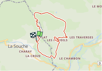
13,6 km | 23 km-effort
5h 18min
![](https://static1.geolcdn.com/siteimages/upload/files/16400158638029165_repeat_loop_refresh_sync_direction_icon.png)
Ja
![Tocht Stappen Jaujac - 07 jaujac rocher de l aigle - Photo](https://media.geolcdn.com/t/375/260/1a765c03-1770-4ba1-9c9c-9314823e934b.jpg&format=jpg&maxdim=2)
![Stappen Stappen](https://static1.geolcdn.com/sitytour/trail-icons/101.png)
07 jaujac rocher de l aigle
Stappen
Gemakkelijk
(1)
Jaujac,
Auvergne-Rhône-Alpes,
Ardèche,
France
![](/images/other/stat-length.png)
11,2 km | 19,7 km-effort
6h 23min
![](https://static1.geolcdn.com/siteimages/upload/files/16400158638029165_repeat_loop_refresh_sync_direction_icon.png)
Ja
![Tocht Stappen Meyras - neyrac les bains - Photo](https://media.geolcdn.com/t/375/260/ext.jpg?maxdim=2&url=https%3A%2F%2Fstatic1.geolcdn.com%2Fsiteimages%2Fupload%2Ffiles%2F1553511878bg_sport_marche.png)
![Stappen Stappen](https://static1.geolcdn.com/sitytour/trail-icons/101.png)
neyrac les bains
Stappen
Gemakkelijk
(1)
Meyras,
Auvergne-Rhône-Alpes,
Ardèche,
France
![](/images/other/stat-length.png)
4,4 km | 6,8 km-effort
1h 36min
![](https://static1.geolcdn.com/siteimages/upload/files/16400158638029165_repeat_loop_refresh_sync_direction_icon.png)
Ja
![Tocht Stappen Jaujac - ARDECHE, JAUJAC. .PONT DE L ECHELLE O - Photo](https://media.geolcdn.com/t/375/260/306eb66a-9a51-42c8-b3b4-a2c469fe7bd7.jpg&format=jpg&maxdim=2)
![Stappen Stappen](https://static1.geolcdn.com/sitytour/trail-icons/101.png)
ARDECHE, JAUJAC. .PONT DE L ECHELLE O
Stappen
Medium
Jaujac,
Auvergne-Rhône-Alpes,
Ardèche,
France
![](/images/other/stat-length.png)
5,1 km | 8,3 km-effort
2h 33min
![](https://static1.geolcdn.com/siteimages/upload/files/16400158638029165_repeat_loop_refresh_sync_direction_icon.png)
Neen
![Tocht sport La Souche - De la Souche à Jaujac - Photo](https://media.geolcdn.com/t/375/260/3ee312a7-57c4-41b3-8f57-e35dcae92908.jpg&format=jpg&maxdim=2)
De la Souche à Jaujac
sport
Heel gemakkelijk
La Souche,
Auvergne-Rhône-Alpes,
Ardèche,
France
![](/images/other/stat-length.png)
13,3 km | 18 km-effort
Onbekend
![](https://static1.geolcdn.com/siteimages/upload/files/16400158638029165_repeat_loop_refresh_sync_direction_icon.png)
Neen
![Tocht Stappen Jaujac - 07_jaujac_Orgues_9km360m - Photo](https://media.geolcdn.com/t/375/260/944ad327-537f-4f2c-8001-5010f7cb1f7d.jpg&format=jpg&maxdim=2)
![Stappen Stappen](https://static1.geolcdn.com/sitytour/trail-icons/101.png)
07_jaujac_Orgues_9km360m
Stappen
Medium
Jaujac,
Auvergne-Rhône-Alpes,
Ardèche,
France
![](/images/other/stat-length.png)
9,1 km | 13,8 km-effort
3h 7min
![](https://static1.geolcdn.com/siteimages/upload/files/16400158638029165_repeat_loop_refresh_sync_direction_icon.png)
Ja
![Tocht Stappen Barnas - 231220 Barnas - Photo](https://media.geolcdn.com/t/375/260/a3dea727-4541-483e-aee3-864f9a0bf52c.jpg&format=jpg&maxdim=2)
![Stappen Stappen](https://static1.geolcdn.com/sitytour/trail-icons/101.png)
231220 Barnas
Stappen
Medium
Barnas,
Auvergne-Rhône-Alpes,
Ardèche,
France
![](/images/other/stat-length.png)
6,7 km | 9,9 km-effort
2h 15min
![](https://static1.geolcdn.com/siteimages/upload/files/16400158638029165_repeat_loop_refresh_sync_direction_icon.png)
Ja
![Tocht Stappen Thueyts - 231217 Thueyts-Brige - Photo](https://media.geolcdn.com/t/375/260/ext.jpg?maxdim=2&url=https%3A%2F%2Fstatic1.geolcdn.com%2Fsiteimages%2Fupload%2Ffiles%2F1553511878bg_sport_marche.png)
![Stappen Stappen](https://static1.geolcdn.com/sitytour/trail-icons/101.png)
231217 Thueyts-Brige
Stappen
Gemakkelijk
(1)
Thueyts,
Auvergne-Rhône-Alpes,
Ardèche,
France
![](/images/other/stat-length.png)
5,7 km | 9,6 km-effort
2h 11min
![](https://static1.geolcdn.com/siteimages/upload/files/16400158638029165_repeat_loop_refresh_sync_direction_icon.png)
Ja
![Tocht Stappen La Souche - La Souche : de Montflat au Rocher du Midi avec un retour par les Rudils - Photo](https://media.geolcdn.com/t/375/260/3e2147d5-d303-4eae-a8a3-a1954222c9b1.jpg&format=jpg&maxdim=2)
![Stappen Stappen](https://static1.geolcdn.com/sitytour/trail-icons/101.png)
La Souche : de Montflat au Rocher du Midi avec un retour par les Rudils
Stappen
Moeilijk
La Souche,
Auvergne-Rhône-Alpes,
Ardèche,
France
![](/images/other/stat-length.png)
6,8 km | 12,8 km-effort
2h 53min
![](https://static1.geolcdn.com/siteimages/upload/files/16400158638029165_repeat_loop_refresh_sync_direction_icon.png)
Ja